
Gulshan Empire Location — Wave City, Sector 1, NH-24.
The Gulshan Empire location sits on NH-24 — officially NH-9, the Delhi–Meerut Expressway corridor — inside the full Wave City township guide (~4,200-acre IGBC Platinum, Ghaziabad). Below is the full connectivity dossier: expressways, the Namo Bharat RRTS, metro, rail, airports, schools, hospitals and malls — stated as distances, sourced and hedged, not as the drive-time claims you'll see elsewhere.
Project RERA: UPRERAPRJ166511/05/2026 (as filed by the developer) · Verify on up-rera.in
Marketed by Vidastu Advisory · UP-RERA Agent UPRERAAGT000309/01/2026 · No buyer-side fees
Gulshan Empire — by Gulshan Empire Estate LLP (RERA UPRERAPRJ166511/05/2026) — is at Plot GH-2B, Sector 1, Oak Wood Enclave, Wave City, Ghaziabad, UP 201015, on NH-24 (officially NH-9) / the Delhi–Meerut Expressway corridor, inside the ~4,200-acre Wave City township (IGBC pre-certified Platinum). The Eastern Peripheral Expressway interchange is at nearby Dasna; the Namo Bharat (RRTS) is operational, nearest station Ghaziabad ~8–10 km. Last updated: 4 June 2026.
One Plot on the East-NCR Spine.
Most listings name a township and stop there. Here is the exact parcel: Plot GH-2B, Sector 1, in the Oak Wood Enclave pocket of Wave City — a 5.56-acre, low-density site fronting the NH-24 corridor that east NCR has been building around for a decade.
"NH-24" is the name everyone still uses, but the highway was formally renamed NH-9 (Delhi–Hapur–Moradabad) and now runs alongside the Delhi–Meerut Expressway (National Expressway 3). We lead with the correct designation because credibility, on a ₹2-crore decision, starts with getting the road name right.
| Address field | Detail |
|---|---|
| Plot | GH-2B |
| Sector / pocket | Sector 1, Oak Wood Enclave |
| Township | Wave City |
| Highway frontage | NH-24 (NH-9) / DME |
| City / district | Ghaziabad |
| State | Uttar Pradesh |
| Pincode | 201015 |
Township-level coordinates ≈ 28.6465° N, 77.5084° E (approx.). The exact Sector 1 pin is confirmed on a site visit — we don't assert false precision. Project overview →
On the Road Grid to Everywhere.
The single strongest fact about this address is the road network it touches. Wave City's internal grid meets NH-24 at the gate, and from there three expressways open up Delhi, Noida, Greater Noida and the Yamuna corridor — often without entering Delhi's congested core.
| Route | Relationship to the site | What it unlocks |
|---|---|---|
| NH-24 (officially NH-9) | direct frontage | Delhi ↔ Hapur ↔ Moradabad; the township's primary access. |
| Delhi–Meerut Expressway (NE-3) | runs alongside | High-speed link toward east Delhi (Nizamuddin) and Meerut. |
| Eastern Peripheral Expressway (NE-2) | interchange at Dasna | Greater Noida, Yamuna Expressway, Faridabad, Sonipat — bypassing Delhi. |
| DND Flyway | ~12 km (approx.) | Corridor toward South Delhi. |
Relationships are geographic; distances approximate and by road. The EPE interchange at Dasna is the quiet hero here — it routes you to Greater Noida and the Yamuna Expressway (and onward to Jewar airport) without the Delhi crawl. More on Wave City's road grid →
Mass Transit, Stated Honestly.
This is where most competitor pages go quiet — and where the truth is actually a strong story. The Delhi–Meerut Namo Bharat (RRTS) is fully operational, the Red Line terminus is a short hop, and we flag clearly what is real versus what is only proposed.
Metro & RRTS — operational
| Station | Distance (approx.) |
|---|---|
| Shaheed Sthal (New Bus Adda) — Red Line terminus | ~8–10 km |
| Ghaziabad — Namo Bharat (RRTS) | ~8–10 km |
| Duhai / Duhai Depot — RRTS | ~10–14 km |
| Mohan Nagar — Red Line | ~15 km |
| Vaishali — Blue Line | ~14 km |
The full Delhi–Meerut RRTS (Sarai Kale Khan ↔ Modipuram, ~82 km, 16 stations) has been operational since early 2026 — a genuine, verifiable advantage.
Proposed & rail
| Reference | Status / distance |
|---|---|
| Dasna RRTS station | proposed only* |
| Ghaziabad Junction (rail) | ~11 km |
| New Bus Adda (Ghaziabad) | ~8–10 km |
| Anand Vihar ISBT (Delhi) | ~20–22 km |
*A "Dasna" station appears only in the separate, still-planning Ghaziabad–Jewar RRTS corridor (target ~2030–31) — it is not on the current Delhi–Meerut line. Treat any "Dasna RRTS" claim as proposed, not existing. Distances approximate and by road.
Three Airports, One Corridor.
Few NCR addresses can name three airports in their catchment. The headline-safe truth: Hindon is the nearest operational option, IGI handles the long-haul, and Jewar — the region's game-changer — has been in commercial operation since 15 June 2026.
We state the Jewar status precisely: Noida International Airport has been in commercial operation since 15 June 2026 and is carrying passengers. No metro or RRTS line reaches it yet — so we don't imply a rail link that doesn't exist. The drive uses the DME → EPE → Yamuna Expressway chain.
Why Jewar matters for Wave City →| Airport | Status | Distance (approx.) |
|---|---|---|
| Hindon (HDO), Ghaziabad — domestic | operational | ~15–18 km |
| Indira Gandhi Intl (IGI / DEL) | operational | ~45 km |
| Noida Intl, Jewar (DXN) | flights from 15 Jun 2026 | ~60–70 km |
Distances approximate and by road. Hindon (domestic, IndiGo) is the nearest operational airport; IGI is ~60–75 min off-peak; Jewar routes via DME → EPE → Yamuna Expressway. Back to the project →
Where the Commute Actually Goes.
For most buyers the address is judged by the office run and the weekend places. Here are the everyday destinations as by-road distances. We deliberately avoid "12 minutes to Sector 62" — that's ~18 km, and a minutes claim on that distance is the classic trap UP-RERA treats as misleading.
| Destination | Distance (approx.) | Note |
|---|---|---|
| Noida Sector 62 (IT / corporate) | ~18 km | Via NH-24 / NH-9. |
| Noida Sector 63 (IT) | ~16 km | Adjacent IT belt. |
| Indirapuram (Shipra Mall cluster) | ~13–15 km | Schools, retail, dining. |
| Anand Vihar, east Delhi | ~20–22 km | Along the Delhi–Meerut Expressway. |
| Site IV, Sahibabad industrial | ~8 km | Bulandshahr Road industrial area. |
| Greater Noida / Knowledge Park | ~25–35 km | Via the EPE interchange at Dasna. |
By-road distances, approximate; drive times vary with traffic and are deliberately not stated for longer legs. Expect ±2–3 km depending on which Wave City gate and route you take. Read our honest review of the address →
The brochure's drive-times, on the record
We plan by distance; the developer's brochure states minutes. Both belong on the table — here are the official brochure claims, verbatim, so you can judge them against the distances above.
| Destination | Brochure drive-time |
|---|---|
| DPS Ghaziabad | 10 mins |
| Santosh Hospital | 12 mins |
| Manipal Hospital | 15 mins |
| IMS Ghaziabad | 15 mins |
| St. Xavier's World School | 18 mins |
| ABES Engineering College · Sunder Deep · Jaypee Institute | 20 mins |
| GD Goenka Public School | 20 mins |
| Noida Electronic City Metro | 20 mins |
| Hindon Airport | 24 mins |
| Gaur City Mall | 24 mins |
| Shipra Mall | 25 mins |
| Anand Vihar ISBT | 30 mins |
| Binge Central | 30 mins |
| Kailash Hospital · HRIT · BIT | 40 mins |
| Subharti University | 45 mins |
| Jewar International Airport · IGI Airport | 60 mins |
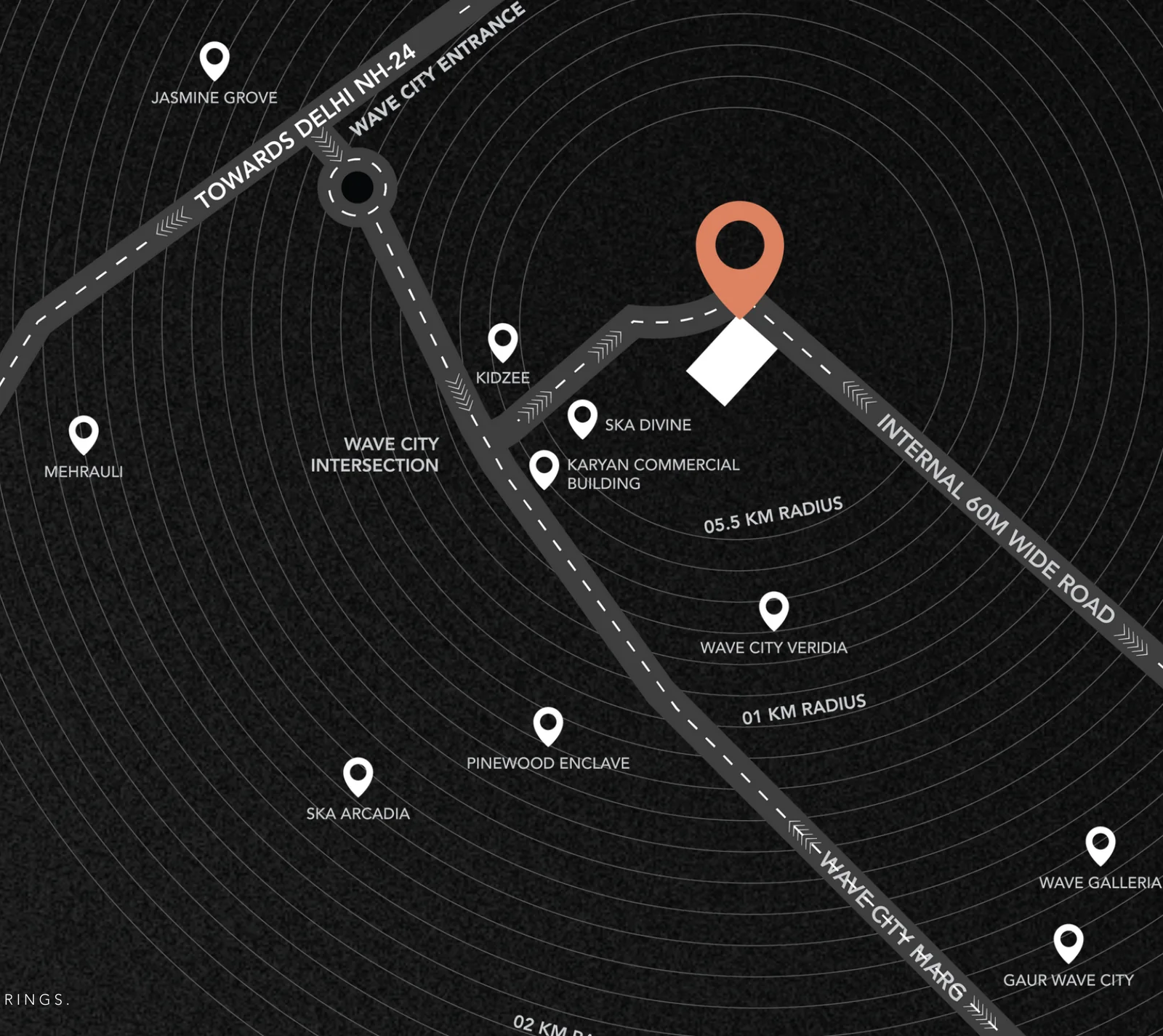
Source: the developer's brochure (June 2026) — these are the promoter's claims, reproduced for the record; minutes are traffic-dependent and not our representation. Per the same brochure's radius map: Kidzee, SKA Divine and the Karyan commercial block sit within ~0.5 km of the plot; Wave City Veridia and Pinewood Enclave ~1 km; SKA Arcadia, Wave Galleria and Gaur Wave City ~2 km — with the project fronting the township's internal 60 m-wide master-plan road.
The Daily-Life Map.
A township lives or dies on what's inside the gate and what's a short drive away. We name only what's verifiable, mark distances as indicative, and are honest about the gaps — there is no full multi-specialty hospital inside the township yet, and pretending otherwise would only invite correction.
Schools
Operational CBSE schools in / adjacent to the township include DPS Wave City and Hi-Tech World School, with Wave City School, Kanha Makhan Public School and Oxford International School also in the area (~1–4 km).
We avoid copying competitor "X km" tables for distant schools — several are unverified. Confirm current operating status before relying on any figure.
Healthcare
In-township clinics and diagnostic labs (incl. Dr. Lal PathLabs) cover day-to-day needs. Full multi-specialty hospitals — Shivalik (~12 km), Manipal (~15 km), Yashoda (~18 km) — sit on the Ghaziabad side.
No large hospital is inside the township today; distances above are indicative and by road.
Shopping & dining
In-township retail includes Wave Galleria and the Dream Bazaar precinct. Nearby: Pacific Mall (~6 km), with Shipra and Gaur City malls within ~15–20 km. A Haldiram's anchors the SKA Arcadia cluster.
Distances indicative; named F&B beyond the township is best checked live on maps.
Place names are provided for orientation only and are not endorsements; current operating status and exact distances should be verified independently. The strongest, most defensible facts are the in-township schools and the ~6 km Pacific Mall. See on-site amenities →
An Address Inside a City.
Gulshan Empire doesn't stand alone on a highway — it sits inside Wave City, a ~4,200-acre master-planned township that is IGBC pre-certified Platinum, with its own internal road grid, schools, retail and green spaces already on the ground.
That matters for an address you'll live with for years: the social infrastructure is a working ecosystem, not a future promise, and a low-density 5.56-acre plot within it keeps its own community intimate. We say "pre-certified," never "certified," and any resident counts are per the developer, not asserted as fact.
The Map Tells You Half. The Drive Tells You the Rest.
Distances on a page are one thing; the feel of the NH-24 approach, the township gate and the Sector 1 plot is another. Book a site visit and we'll confirm the exact pin, walk the connectivity, and answer every "how far is…" in person.
No buyer-side fees · brokerage is paid by the developer · your details are shared only with the RERA-registered promoter to process your enquiry.
Prefer to talk first? Call or WhatsApp Vidit Kaushik at +91 98114 05300.
Book a Site Visit
We'll fix a slot, share the exact location pin and pick you up if needed — confirmed on WhatsApp.
Received!
Vidit will confirm your site-visit slot and the location pin on WhatsApp shortly.
By submitting you consent to be contacted about this project and to your details being shared with the RERA-registered promoter. No spam · no buyer-side fees.
Gulshan Empire Location — FAQ
Where exactly is Gulshan Empire located?
Gulshan Empire is at Plot GH-2B, Sector 1, Oak Wood Enclave, Wave City, Ghaziabad, Uttar Pradesh 201015 — on NH-24 (officially NH-9), the Delhi–Meerut Expressway corridor, inside the ~4,200-acre Wave City township (IGBC pre-certified Platinum). The Eastern Peripheral Expressway interchange is at nearby Dasna and the Delhi–Ghaziabad–Meerut Namo Bharat (RRTS) is operational, with the nearest station at Ghaziabad about 8–10 km away. Project RERA: UPRERAPRJ166511/05/2026 (as filed by the developer).
What is the nearest metro and RRTS station to Gulshan Empire?
The nearest Delhi Metro station is Shaheed Sthal (New Bus Adda), the Red Line terminus, approximately 8–10 km away. The nearest Namo Bharat (RRTS) station is Ghaziabad, also roughly 8–10 km away and part of the fully operational Delhi–Ghaziabad–Meerut corridor. A Dasna RRTS stop is sometimes mentioned, but it belongs to the separate, still-planning Ghaziabad–Jewar corridor and is proposed only — not built. Distances are approximate and by road.
How far is Gulshan Empire from Jewar (Noida International) Airport and IGI Airport?
Noida International Airport at Jewar is roughly 60–70 km away via the Delhi–Meerut Expressway, Eastern Peripheral Expressway and Yamuna Expressway; it has been in commercial operation since 15 June 2026. Indira Gandhi International (IGI) Airport, Delhi, is about 45 km away. The nearest operational airport is Hindon Airport, Ghaziabad (domestic), approximately 15–18 km away. All distances are approximate and by road.
How far is Gulshan Empire from Noida, Indirapuram and Anand Vihar?
Noida's IT hubs at Sector 62 and Sector 63 are roughly 16–18 km away via NH-24 / NH-9. Indirapuram (and the Shipra Mall cluster) is about 13–15 km away. Anand Vihar in east Delhi is roughly 20–22 km, reachable along the Delhi–Meerut Expressway. Greater Noida and the Yamuna Expressway connect via the Eastern Peripheral Expressway interchange at Dasna. These are approximate by-road distances; drive times vary with traffic.
What schools and hospitals are near Gulshan Empire in Wave City?
Within or adjacent to the Wave City township are operational CBSE schools including Delhi Public School (DPS) Wave City and Hi-Tech World School. For healthcare, the township has clinics and diagnostic labs, while full multi-specialty hospitals — such as Shivalik, Manipal and Yashoda — are roughly 12–18 km away on the Ghaziabad side. Retail includes in-township options like Wave Galleria and Dream Bazaar, with Pacific Mall about 6 km away. Distances are approximate; please verify current operating status before relying on any single figure.
Is Gulshan Empire well connected to the expressways?
Yes. Wave City sits directly on NH-24 (officially NH-9), which runs alongside the Delhi–Meerut Expressway (National Expressway 3). The Eastern Peripheral Expressway interchange is at nearby Dasna, linking the address to Greater Noida, the Yamuna Expressway, Faridabad and Sonipat without entering Delhi's core. The DND Flyway toward South Delhi is roughly 12 km away. Distances are approximate and by road, and drive times are traffic-dependent.
Wave City Guide
The ~4,200-acre township around the address — infrastructure, sectors and the IGBC story.
Project Guide
The full picture — scale, configurations, developer and RERA, in one place.
Price
Base rate, the early-bird advantage, PLC, floor-rise and GST — itemised and hedged.
Floor Plans
Both configurations and the master plan, with super and carpet areas.
Amenities
What's on the 5.56 acres — the RERA-filed community building and the master-plan set.
RERA Verification
Verify the registration and filed figures yourself, step by step, on up-rera.in.